1.1 基于Kriging法的情景模拟方法
1.1.1 基于Kriging插值的城市内涝情景模拟
降雨径流模型考虑降雨的物理过程,通过水力学公式可计算降雨引发内涝的时空分布,而且模型对城市降雨积水的具体特征做了大幅简化,在保证一定的计算精度的前提下大幅降低了计算时间.目前,世界范围内有许多可用的城市降雨径流模型,例如,SWMM和伊利诺城市排水区域模拟(Illinois urban drainage area simulator, ILLU-DAS)等[8].这类模型基本可以满足城市暴雨排水系统模拟的需要.但由于是一维水动力模型,所以不适合做内涝评估分析.
Kriging插值法的提出为内涝时空分布评估提供了可能.该方法通过对积水点采样数据及地理特征合理分析其可能出现的演化过程,进而选择合适的拟合模型创建淹没分析图.Kriging插值方法不仅能量化已知点之间的空间自相关性,并可说明采样数据在预测区域范围内的空间分布情况[9].
与反距离权重法类似,Kriging插值法对周围的测量值进行加权以得出未测量位置的预测.其计算公式[10]为
其中, si为第i个积水点位置; Z(si)为第i个位置的测量值; λi为第i个位置处的测量值的未知权重; s0为预测位置; N为测量值数.
1.1.2 半变异函数模型优选及方法检验
1)半变异函数及拟合模型:Kriging法插值过程中,有限积水点扩散区域化模型是随机且规律性的.因此,模型建立需要由合适的半变异函数实现从有限至区域化的相似扩散演化,使半变异函数曲线与积水点数据达到拟合,最终用于模型预测.
半变异函数计算公式[11]为
其中, h为距积水点si的距离; γ(h)为h处的积水深度变异函数; N(h)为分割距离为h时样本点的总个数; Z(si)、 Z(si+h)分别为积水点si和si+h处的积水深度测量值.
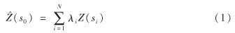
2)半变异函数的模型优选:Kriging法中,式(2)只能反映出积水点深度本身的变异特征和空间分布,不能反映出在不同空间滞后距离上的空间变异特征以及积水点的空间异质性定量化特征,故需要通过常用半变异函数的拟合模型对已知数据点离散关系进行拟合[11].拟合模型由半变异函数根据已知测量点的空间自相关性确定,如图1[12].目前常用的半变异模型有稳定、球面、指数和高斯模型等.选择合适的拟合模型是空间插值的前提条件,直接影响空间插值的精度结果.
图1 半变异函数拟合曲线示例[12]
Fig.1 Examples of semi-variation fitting curves[12]
图1中的C0是块金值,为半变异函数曲线在γ(h)轴上的截距,表示积水深度受到随机因素影响的空间变异; C为偏基台值,即半变异函数值达到稳定时的增量,用于反映积水深度因空间结构引起的变异; C0+C为基台值,表示积水深度总的空间变异; C0/(C0+C)为基底效应,表示空间的变异特征,该值越大,说明积水深度的空间变异更多是由随机成分引起的; a为变程,即半变异函数第1次达到稳定时所对应的采样距离,表示积水深度的空间自相关范围.
最优模型主要通过无偏性和一致性来判断.前者常采用偏差均值(Kriged reduced mean error, KRME)指标来衡量; 后者则采用一致性系数(Kriged reduced mean square error, KRMSE)指标判定.KRME越接近0,表示无偏估计的效果越佳.KRMSE越接近1,表示模型越好[9,12].KRME与KRMSE计算公式分别为
其中, 为第i个测量点的实际值; Zi为第i个测量点的估计值; n为测量点数目; δ为实际值的标准偏差.
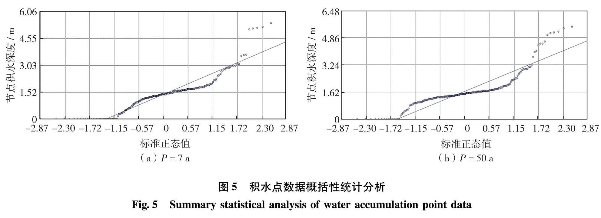
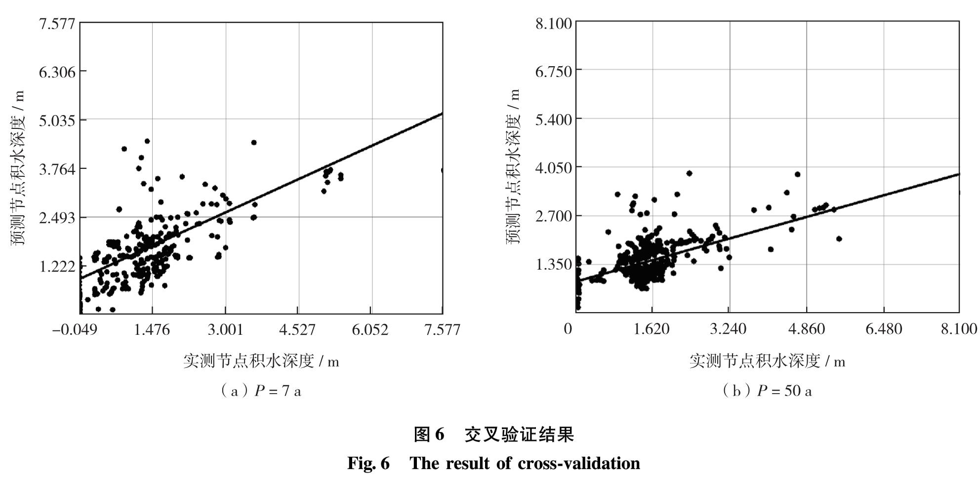
3)检验方法:为保证插值精度,在模型优选的基础上进一步采用交叉检验(cross-validation)进行插值方法验证.原理是在给定的样本模型中汇总之后留出部分样本用于建立模型进行预测,并求出这小部分样本的预测误差[9].
1.2 研究区域概况
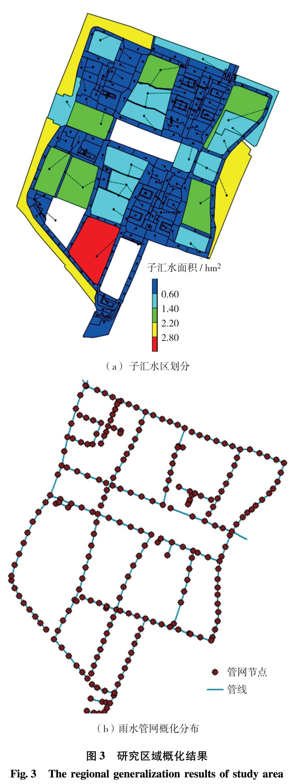
研究区域地处兰州市靠近黄河南岸的七里河区,如图2.该城区位于市内中南部,地理坐标为103°36″E—103°54'54″E,35°50'32″N—36°06'12″N.地势南高北低,平均海拔2 321 m.南部为石质山地,地形特征为山高、谷深、坡陡,岩石裸露.七里河区境内属大陆性半干旱气候.主要特征是:四季分明,冬夏长,春秋短.雨热同季,垂直气候变异显著.气温、热量和光照随海拔由南向北升高; 年平均降雨量为327 mm,由南到北逐渐降低.校区占地87 hm2,在开发之前多为平顶屋面,其数量少且占地面积有限; 周围多分布山杨、桦树群体及少量灌木.这类植物渗透系数高,对水分蒸散与入渗作用显著.校园开发后土地利用类型多样化,其中,绿地面积占比为42%,不渗透面积占比为57%(包括新开发地块4%、建筑物10%、开阔空地14%和道路29%).
图2 研究区域范围(线内)
Fig.2 The study area(in line)
利用校园雨水管网计算机辅助设计(computer aided design, CAD)图将研究范围划分为子汇水区226个.经统计,研究区域概化管道总长为8 804.55 m,汇水区总面积64.11 hm2,概化结果如图3.
图3 研究区域概化结果
Fig.3 The regional generalization results of study area
1.3 暴雨强度公式的确定及设计降雨过程线
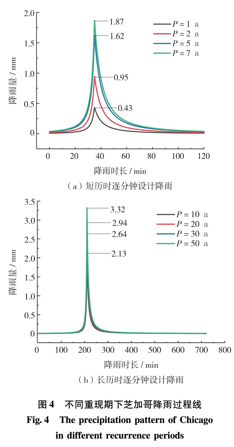
因缺乏兰州市历年降雨气象水文资料,所以本研究降雨数据由暴雨强度公式生成,该公式由王杰等[13]根据兰州市国家基本气象站1960—2014年的降雨资料,通过皮尔逊-Ⅲ型分布拟合得出.降雨强度公式为
其中, i为降雨强度(单位:mm/min); P为降雨重现期(单位:年); t为降雨历时(单位:min).在该模型中,采用芝加哥降雨模式描述降雨过程.这种降雨模式可以概括大多数降雨类型,能反映出地表径流与出流量峰值,因此适用于区域和雨水系统设计的预评价[14].研究中采用雨峰系数为0.291,其主要目的是分析早期降雨高峰对研究区域径流和积水的影响.选取1、2、5和7 a重现期(降雨历时短,为2 h)和10、20、30和50 a重现期(降雨历时长,为12 h)绘制芝加哥降雨过程线如图4.本研究中实测降雨数据采用2018年6月、7月及2019年6月、7月共4个月的降雨特征和对应的流量数据,降雨编号依次为201806、201807、201905和201907(表1).
图4 不同重现期下芝加哥降雨过程线
Fig.4 The precipitation pattern of Chicago in different recurrence periods
表1 实测降雨数据
Table 1 Measured rainfall data
![图1 半变异函数拟合曲线示例[12]<br/>Fig.1 Examples of semi-variation fitting curves[12]](2021年1期/pic42.jpg)