1.1 数学模型
地质对象由多个不同的地质单元构成,且具有空间连续性,因此,地质体模型是一个连续实体网络. 如图1,假设将地质结构曲面S定义为由欧氏三维空间上的曲线多边形面单元或连续小面片的集合,则该曲面无需闭合或相连.
设定离散拓扑模型A(Ω,N),Ω=Ω(S)是描述曲面S的所有点的集合,N=│Ω│是Ω集合中点的数量. 在此基础上,设定离散模型M(A(Ω,N),φ,λ), 其中,φ(α)={φx(α),φy(α),φz(α),…,φv(α),…}, α∈Ω, λ={λ1,λ2,……}, {λi}∑α∈Ω∑vAvi(α)φv(α)=bi, 系数A和b可根据各种不同的约束条件确定.
图1 离散拓扑地质曲面示意图
Fig.1 Geological surface model by DSI
1.2 DSI技术
本研究采用离散光滑插值技术来进行高精度三维曲面的构建. 设φ(k)是定义在所有节点k∈Ω上的m个属性函数集合,φ(k)=(φ1(k),φ2(k),…,φm(k)),(φ1(k),φ2(k),φ3(k))表示k点的几何坐标, φ4(k)表示k点上的曲面法向矢量, φi(k)(4<i≤m)则是k点定义在曲面S上的标量或张量属性.
任意曲面S均可以由一个M×N的矩阵来表达其空间位置和属性分布,用一个m维行矩阵φ(k)=[φ1(k),φ2(k),…,φm(k)] 表达Ω上某节点k∈Ω的所有属性,用一个N维列矩阵φi=[φi(1),φi(2),…,φi(N)]T表达定义在Ω集合中所有点的某一个属性i(1≤i≤m). 对于某一个定义在Ω集合中所有点的函数φi, 部分节点的函数值已知,其余节点函数值是未知的,需基于离散光滑插值方法来求解确定.
定义 Y为节点y∈Ω的集合, φi(y)已知; U为节点u∈Ω的集合, φi(u)未知; U=Ω-Y, φi =[φi(1),φi(2),…,φi(N)]T=[φi(Y),φi(U)]T, 因为网格节点的编号方式与排序均不影响拟合插值,故可对φ矩阵中元素的排列顺序进行交换,从而将φ矩阵表示成任意2个已知子矩阵与未知子矩阵的和,形成式(1)的简洁数学表达.
φ=[φI
φL]{φI=[φ(i1)
φ(in)], iα∈I
φL=[φ(l1)
φ(lm)], lβ∈L(1)
在进行三维建模时,不同可靠度约束条件的处理方法不同. 必须精确表达测量、钻孔和平硐记录等原始的空间位置及产状数据,对此类型数据处理时,需增加曲面描述的节点数量(即增加Ω空间容量). 基于地质对象的复杂性,在对地质人员的地质解释、物探数据解释等模糊性数据进行处理时,可对曲面S建立一系列不同的约束条件,并根据约束条件、地质可靠性的差异设置不同的置信因子,从而达到控制约束条件对曲面S影响的目的.
因此,可以用一个N维列矩阵来表达定义在Ω集合中所有点的某一个属性i(1≤i≤m), 若属性i有n个地质解释约束条件t(t=1,2,…,n), 则可以用一个N维行矩阵和一个常数来定义该约束条件Atφi=Bt, 其中, At=[At(1), At(2),…,At(N)], Bt为第t项约束条件对应常数.
约束条件对Ω空间容量无影响,故属性函数不完全满足约束关系,即|At(k)φi(k)-Bt|2>0. 需要根据每个约束条件的可靠性设置一个正数置信因子ω2t, 并考虑所有的约束条件
ρ(φi(k))=∑tω2t|At(k)φi(k)-Bt|2(2)
在进行拟合插值时,ρ(φi)越小,越能准确地吻合约束条件; 可靠度大的约束条件,ω2t的值也大,达到相同ρ(φi)时,要求|Atφi-Bt|2越小越好,即严格遵守了约束条件.
接下来则需要确定出能使全局粗糙度与线性约束之和R*(φ)最小的φ(k)函数,从而用φ(k)对曲面S进行估计. 设R(φi|k)是定义在节点k∈Ω上的属性函数φi的局部粗糙度, vα(k)是定义在节点k邻域N(k)上所有点的权函数, u(k)是定义在节点k∈Ω上所有点的权函数,则有
R(φi|k)=|∑α∈N(k)vα(k)φi(α)|2=
|vk(k)φi(k)+∑(α∈N(k))/(α≠k)vα(k)φi(α)|2(3)
vk(k)=-∑(α∈N(k))/(α≠k)vα(k)(4)
R(φi|k)=(vk(k))2×
|φi(k)-1/(∑(α∈N(k))/(α≠k)vα(k))[∑(α∈N(k))/(α≠k)vα(k)φi(α)/( / )]|2(5)
φ^-i(k)=1/(∑(α∈N(k))/(α≠k)vα(k))[∑(α∈N(k))/(α≠k)vα(k)φi(α)/( / )](6)
式(6)中, φ^-i(k)是定义在点k的邻域N(k)上,不包括k点的属性函数,按照该点的权函数vα(k)(α∈N(k), α≠k)得到的平均函数值为
R(φi|k)=(vk(k))2|φi(k)-φ^-i(k)|2(7)
φi(k)与φ^-i(k)差值的绝对值越小,节点k在曲面S上越光滑.
累积所有Ω空间上属性函数φi的局部粗糙度,即可求得全局粗糙度
R(φi(k)=∑Nu(k)R(φi|k)(8)
DSI的目标是求解φ,使全局粗糙度R~(φ)最小. 可将R(φ)近似看作R~(φ), 即 R(φ)=R~(φ), 定义ρ(φ|λi)=|∑α∈ΩAi(α)φ(α)-bi|2, 则加上所有约束条件的全局粗糙度R*(φ)=∑α∈Ωμ(k)R(φ|k)+∑t(-overω)iρ(φ|λi),要使R*(φ)达到最优值(最小值),则要求
(R*(φ))/(φ(1))=…=(R*(φ))/(φ(α))=…=
(R*(φ))/(φ(M))=0(9)
进而推导出一个半正定的稀疏线性方程组,采用LDLT法或预条件共轭梯度法可解出方程组的未知量φ(k)={φx(k),φy(k),φz(k),…}. 求得R*(φi(k))=Cφ2i(α)+Dφi(α)+E, 系数C、 D和E不依赖于φi(α),当φi(α)=-D/(2C)时,可得最小度R*(φi), 说明离散光滑插值方法是收敛的.
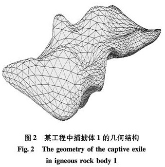
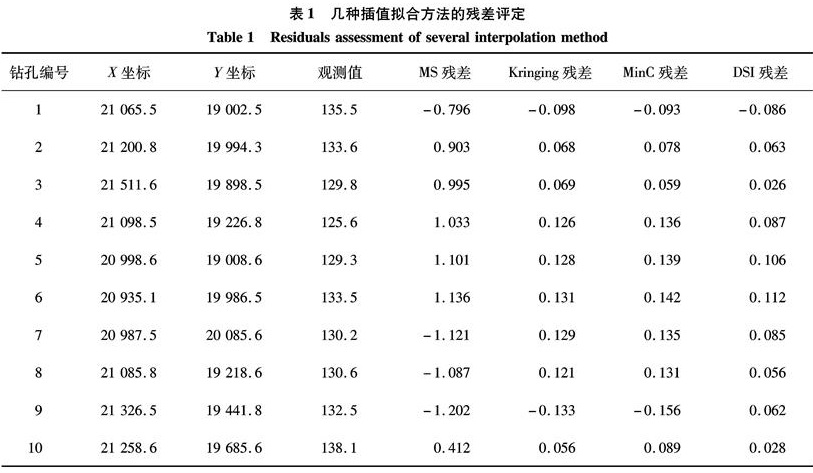
DSI技术的要点是确定出能够使R*(φ)达到最小值的φ(k)函数,在理解该方法数学原理的基础上,可以进一步对其拟合精度进行实验验证.